General Information of Alegria, Surigao del Norte
1. Geographic location & territorial jurisdiction
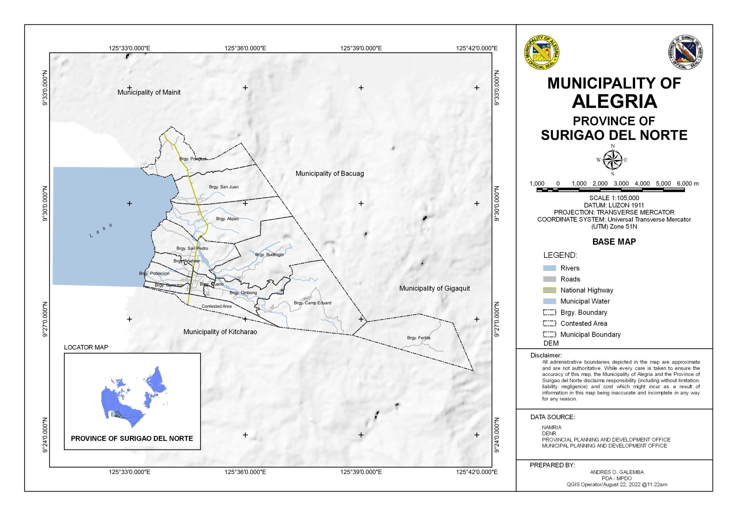
The Municipality of Alegria in the Province of Surigao del Norte, at Caraga Region, is situated at the geographical coordinates of 9°28′00″N 125°34′36″E. It is bounded in the north by the Municipalities of Mainit and Tubod, in the east by the Municipality of Bacuag, in the west by Lake Mainit and in the south by the Municipality of Kitcharao.
2. Population and Barangay subdivision
There are twelve (12) barangays comprising the Municipality.Three (3) of which are located in the mountainous area,namely:Camp Eduard,Budlingin and Ferlda.Five (5) belongs to the urban barangays, such as,Poblacion,Julio Ouano,Gamuton,Anahaw and San Pedro;while the rest are classified as rural barangays, namely:Alipao,San Juan, Pongtud and Ombong.
| Barangay | Land Area (Based on DENR in hectares) | Population Census 2015 | Population Census 2020 |
| Alipao | 846.9158 | 2,161 | 2,079 |
| Anahaw | 119.1044 | 1,630 | 1,540 |
| Budlingin | 958.4227 | 630 | 634 |
| Camp Eduard (Geotina) | 1,135.8903 | 505 | 575 |
| Ferlda | 796.2100 | 174 | 243 |
| Gamuton | 65.8702 | 759 | 503 |
| Julio Ouano | 87.0482 | 2,056 | 2,081 |
| Ombong | 343.2004 | 966 | 1162 |
| Poblacion | 160.2262 | 1,871 | 1,821 |
| Pongtud | 579.9362 | 1,536 | 1,551 |
| San Juan | 656.3981 | 1,503 | 1,560 |
| San Pedro | 554.3995 | 2,220 | 2,435 |
| Contested Area | 224.5485 | ||
| Total | 6,528.1705 | 16,011 | 16,184 |
Population Chart
Poverty Incidence Chart
Click here for updated data of Population Profile by barangay based on PSA Population Census Data
3. Topograph & Slope
Alegria’s topography is characterized by rolling terrain with an average elevation of 480 meters above sea level and a maximum elevation of 975 meters of the Kinabutan range. The existence of Surigao mountains in its eastern side and Agusan mountains on the north made the municipality below the typhoon belt. Almost 50% of the entire area is the situational factor that contributes an advantage to Alegria to be highly suitable for agricultural production that allocates the over-all socio-economic developments.
4. Soil Type
There are three major types of soil present in the area. These are the Anao-aon clay loam which covers 25.47% of the whole area; the Bolinao clay covering 63.11% and Kitcharao clay loam with 11.42%. Generally, the soil of this kind is fertile. The organic layer of the soil is thick and not easily removed by rain, wind, fire, and cultivation.
5. Climate
Based on the provincial climate classification, Alegria belongs to climatic Type II. Dry months are April, May, June, and August with the lowest precipitation of 62mm. The driest month is May and the wettest month is December.
The prevailing wind direction is north-east beginning December to February and during this period most of the tropical cyclones that entered the country were experienced which causes flooding to most of the low-lying areas. Easterly winds can be observed during the months of March to May and southwest winds prevailed from June to September.
6. Natural Resources
The municipality is rich in its mountain natural resources which newly discovered caves and waterfalls. One of the tourist waterfalls is the Lumondo falls in Barangay Budlingin. Many waterfalls and caves are located in Barangay Ferlda, the remotest barangay of the municipality.

Municipal Offices